Drone imagery reveals likely sites of future Pakri cliff collapses

Years of drone surveys by University of Tartu geologists have shown that the Pakri Cliffs often erode from below, with seawater washing away soft sandstone until overlying limestone collapses into the sea. The resulting 3D models can identify dangerous areas before a collapse occurs.
Two winters ago, in mid-January, an observation platform at the Pakri Cliffs collapsed into the sea. A 30-meter section of the cliff edge broke away, and the cliff retreated 12 meters in a single event. About 2,800 cubic meters of rock, equivalent to roughly 160 dump truck loads, fell into the water. Although the collapse appeared sudden from above, it could have been anticipated from the side, writes University of Tartu junior research fellow in geology Tiia-Linda Purge.
Not everything is visible from the top
Near Paldiski, the Baltic Klint rises directly from the sea to heights of up to 25 meters. A historic lighthouse dating to the era of Russian czar Peter I stands at the edge, alongside well-worn visitor trails. Geologists have studied this section of the cliff for more than two centuries, focusing mainly on its rock layers and composition. Until now, however, cliff retreat has largely been measured from above by comparing historical maps and aerial imagery.
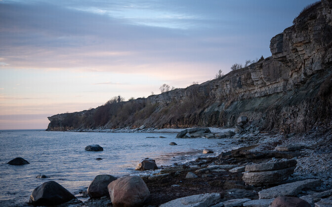
The cliff edge tells only part of the story. The Pakri Cliffs resemble a layer cake. The upper seven meters consist of limestone, with harder, fractured rock near the top and more clay-rich, sandy, and fragile layers below. Beneath that lies green glauconitic sandstone, once studied as a source material for potassium fertilizer, followed by black shale, also known as graptolite argillite, and softer sandstones at the base. These rocks were deposited on the floor of an ancient sea nearly 500 million years ago.
If scientists evaluate cliff retreat solely by studying the edge, they miss what is happening beneath it. A significant part of the process occurs midway down the vertical cliff face, an area inaccessible to people without ropes and difficult to observe from conventional aerial surveys. That is why researchers set out to map the cliff from the side and in three dimensions.
Using drones to reach inaccessible areas
Researchers photographed the cliff using drones in 2015, 2022, and 2024. Software then combined the images into a three-dimensional model, allowing every layer, fracture, and cave to be measured and analyzed on a computer. The team also traced the cliff edge using six aerial photographs covering the period from 1959 to 2024.
The work was far from simple. Drones had to be flown just a few meters from the cliff face and the water's surface while avoiding fallen rock debris and ensuring all key features were captured. Waves and boulder fields prevented researchers from surveying the base of the cliff as closely as they would have liked, and the ceilings of deeper caves remained hidden from view.
The method, known as photogrammetry, more specifically structure-from-motion photogrammetry, involves photographing the same location from multiple angles. Computer vision algorithms identify common points across images and create a three-dimensional model from ordinary photographs. The more sharp, overlapping images available, the more accurate and detailed the result.
To detect change over time, researchers aligned models from different years. Precise drone positioning helped with newer surveys, while older datasets required the use of stable reference points that had remained unchanged.
The secret of cliff collapses lies below
Aerial photographs show the Pakri Cliffs have lost more than a football field's worth of land over the past 65 years. The cliff edge retreated by an average of 18 centimeters per year, and by as much as 30 centimeters annually near the historic lighthouse and the collapsed observation deck.
Those rates are similar to coastal cliffs in northern Germany and northwestern Poland, which retreat at rates of 19 and 14 centimeters per year, respectively. Unlike those cliffs, however, Pakri is capped by hard limestone. The cliffs of Osmussaar, which consist entirely of limestone, retreat on average by only seven centimeters per year.
Average figures can be misleading. The cliff does not retreat at a steady pace. Years may pass with little change before a large section suddenly collapses, as happened in January 2024 when the observation deck fell and the cliff retreated 12 meters. Smaller collapses often go unnoticed by the public, but drone models can detect them.
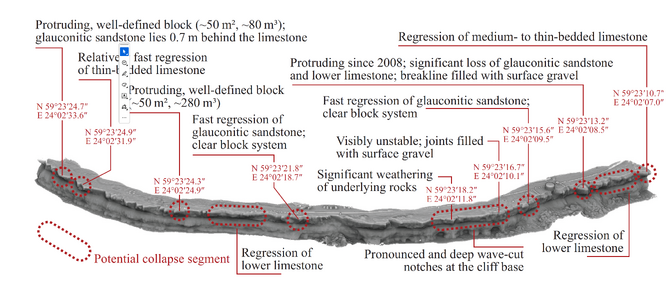
The underlying cause is the interaction between geology and rock layers. Rainwater seeps through fractured limestone and emerges along weaker sandstone layers beneath it. The water gradually washes away the sandstone grain by grain, leaving limestone suspended overhead. Repeated freeze-thaw cycles widen fractures until a rock block finally breaks away. Both the observation deck collapse and a collapse near the lighthouse in 2021 were preceded by significant sandstone erosion beneath the limestone.
The cliff also breaks along existing joint systems (natural rock fractures). Researchers mapped more than 400 joint surfaces from drone models. Two dominant fracture systems, running northwest-southeast and northeast-southwest, create the Pakri coastline's distinctive zigzag shape. The cliff retreats most rapidly where fractures intersect and where underlying sandstone has already been eroded away.
The sea also plays a key role. Waves carve coastal notches (wave-cut undercuts) into the sandstone at the cliff base. Geologists mapped 18 such notches and 19 shallow indentations representing proto-notches in the early stages of formation. These features develop where the rock is naturally weaker. Poorly cemented sandstone yields to wave action, while the black shale layers above it resist erosion longer. As a result, the cliff erodes unevenly, with each layer wearing away at its own pace.
The cliff also has a natural defense mechanism. Fallen limestone blocks accumulate at the base, forming a rubble slope that absorbs wave energy. After the observation platform collapse, a rock barrier nearly five meters high formed in front of the cliff. The protection lasts only until waves carry the debris away and regain access to the base of the cliff.
Mapping hazardous areas
The 3D models help scientists identify locations where sandstone has already eroded from beneath limestone, leaving dangerous overhangs. Based on those findings, researchers mapped potential collapse zones along the Pakri Cliffs. Such maps can help redirect hiking trails away from hazardous areas and warn visitors of potential risks.
Researchers caution that not everything can be predicted. The hazard zones are based on expert assessment rather than precise forecasts because the behavior of such a complex system cannot be predicted with complete accuracy. The visible fractures on the rock surface may represent only part of a much denser network hidden within the cliff. Scientists also lack a full understanding of how the underwater cliff base modifies wave energy.
The team plans to produce a new model at least once a year. The longer the dataset becomes, the better researchers will understand the cliff's natural rhythm and identify areas preparing for future collapses or responding to changing environmental conditions.
While coastal scientists around the world already make extensive use of drones and related surveying technologies, the approach remains relatively new in Estonia. Compared with satellites and aircraft, drones offer a flexible and cost-effective tool that can be deployed exactly where and when it is needed. The Pakri Cliffs demonstrate how this new perspective can advance coastal research in Estonia.
The study was published in the journal Estonian Journal of Earth Sciences.
Editor: Jaan-Juhan Oidermaa, Argo Ideon


